High Line-Elevated NYC Park-Rail Trail
Park Overview:
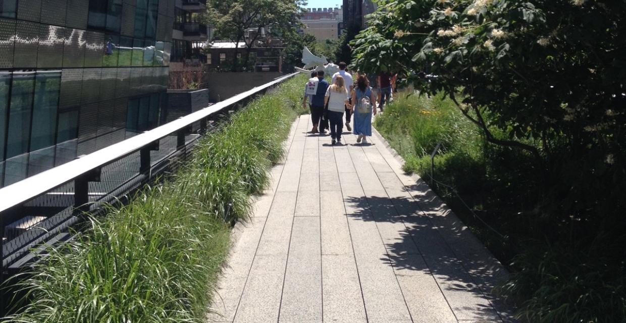
Elevated NYC rails-to-trail park with city views on the lower west side of Manhattan. "Not since Central Park opened in 1857 has a park reshaped New Yorkers’ thinking about public space and the city more profoundly." (New York Times, 9/20/2014)
Park Description:
High Line - Elevated NYC Park-Rail Trail
From 1934 to 1980 an elevated rail line, now called the High Line, connected the rail yards of mid-town Manhattan to an industrial district along the lower West Side of Manhattan. Constructed 30 feet above the ground, it avoided dangerous street crossings, and routed between 10th and 11th streets in its more northern sections the railway avoided association with the unpopular elevated sections of New York's subway system.
After much controversy and considerable effort -- this is New York City -- the High Line opened an initial segment to the public (from Gansevoort Street to West 20th Street) in June 2009. Section 2, extending the walkway to West 30th Street, was opened two years later. Completed in September 2014, the third and final section loops around the Hudson Yards located between West 30th and West 34th Streets. The aerial greenway now measures 1.45 miles.
More than 2M people visited the High Line during its first year; as of September, 2014, the number had grown to 5M per year.
The High Line is part of the New York City Parks & Recreation Department, but is managed by the Friends of the High Line (use Contact Information on this site).
From June 1 to September 30 it is open 7:00am to 11:00pm daily. Check the Friend’s web site for hours in other seasons (opening time is 7:00am throughout the year).
Trails Overview:
The view of the High Line looking upward at its southern terminus from the street at Gansevoort and Washington appears like a cut of meat chopped with a cleaver. A sheer glass wall looms thirty feet overhead; the design seems intended to remind the viewer this is the historic Meatpacking District. Fittingly, according to park docents the very last train to travel the High Line delivered a shipment of frozen turkeys. Much has changed, May 2015 the Whitney Museum of American Art opened a massive new extension (designed by Renzo Piano) snuggled up next to the High Line at this location.
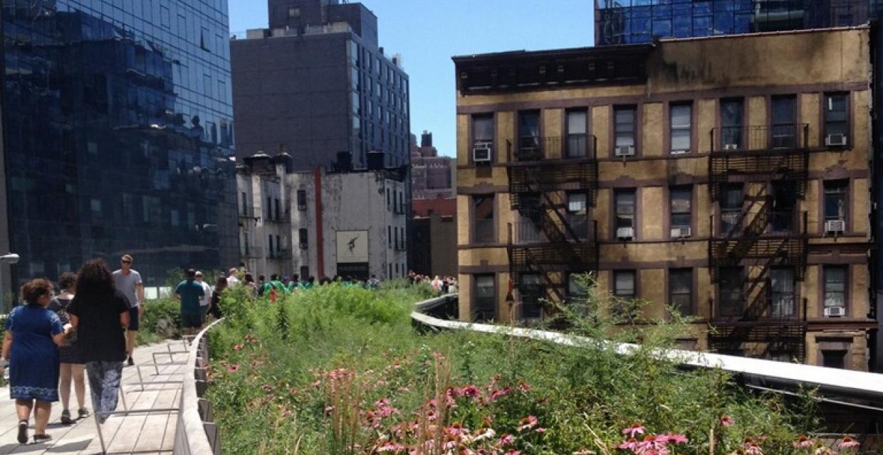
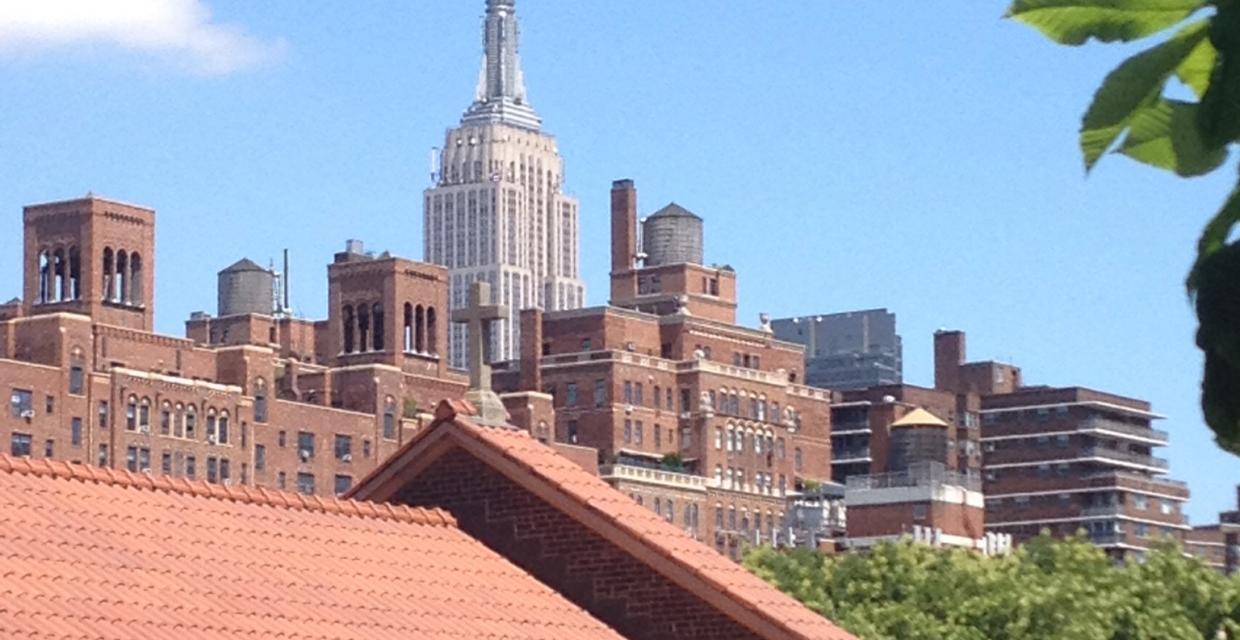
There is much to see along the initial one mile walkway – from striking views of the distant Hudson River and iconic Manhattan buildings poking skyward, to gorgeous landscapes at your feet. Before heading north from the Gansevoort Street entrance it is worth turning back towards the “meat chop” terminus to experience the view. The High Line passes north through a series of beautiful gardens and unique features, including Gansevoort Woodland, the Sundeck and Water Feature (a shallow linear wading pool), Chelsea Market Passage, Chelsea Grasslands, Seating Steps, Wildflower Field and the Radical Bench.
- 10th Avenue Square (between West 17th and West 18th streets) features bleachers that descend through original girders ending with a framed view looking up 10th Avenue. The installation is wheelchair accessible by zigzagging down the rows of bleachers.
- This place in particular reveals original art-deco steel side railings; but they are present throughout the park especially when a section is viewable from the street level. Commonplace round railing were used where the public could not see the original viaduct from the street.
- At 26th Street a viewing spur includes seating facing the street with a large frame that recalls the billboards that blocked the views to the west before the elevated rail viaduct was transformed into a park. The frame is empty, allowing park visitors to view people on the street, and allowing park goers to be seen from the street.
- The park currently ends, or starts, at West 34th Street between 11th Avenue and Westside Highway at the Hudson Yards.
The landscape design itself includes much of the original wild self-seeded plant life and flora that used to naturally inhabit the abandoned corridor – some 300 species of perennials, grasses, shrubs, and trees. The Friends of the Highline web site contains a Bloom List updated by the season. For a printable walkway map use the Web Map link on this (or the Friends web site).
- The deck along the High Line corridor was created from a series of smooth, tapered concrete planks laid in a linear fashion, suggestive of railroad tracks. The walkway flows variously from side to side or into the center or can cover the full deck; it can be narrow, or divided into parallel paths, or become as wide as 60 feet (at 10th Avenue Square). At the Falcone Flyover (between West 25th and West 26th streets) the narrow walkway is elevated above the rail bed which carries visitors through a canopy of sumac and magnolia trees.
- Throughout the park original rail tracks can be seen; more than a third of them have been re-installed. In some places the tracks are embedded in the pathway, in others hidden among various plantings and vegetation.
- After sunset sections of the pathway glow from LED light bars installed low to the ground (and under benches), making possible stellar views of the Manhattan skyline from 30 feet above ground with no overhead lights. Perhaps it needs to be said, the crime rate on the High Line is very low.
Joshua David and Robert Hammond, Co-Founders of Friends of the High Line, were interviewed on NPR's "All Things Considered" on September 3, 2011. The audio tour begins at the corner of Gansevoort and Washington streets. The link includes two versions -- 80 minutes and 12 minutes -- you will need to scan the page to locate them.
Park Acreage:
Not availableMunicipality:
New York City
Elevated NYC rails-to-trail park with city views on the lower west side of Manhattan. "Not since Central Park opened in 1857 has a park reshaped New Yorkers’ thinking about public space and the city more profoundly." (New York Times, 9/20/2014)
High Line - Elevated NYC Park-Rail Trail
From 1934 to 1980 an elevated rail line, now called the High Line, connected the rail yards of mid-town Manhattan to an industrial district along the lower West Side of Manhattan. Constructed 30 feet above the ground, it avoided dangerous street crossings, and routed between 10th and 11th streets in its more northern sections the railway...
Park Acreage:
Not availableMunicipality:
New York CityContact Information
Web Link:
Friends of the High LinePhone:
(212) 500-6035Fees:
NoneDogs in park:
No dogsHike Checklist:
Whether you are going for a day hike or backpacking overnight, it is good practice to carry what we call The Hiking Essentials. These essentials will help you enjoy your outing more and will provide basic safety gear if needed. There may also be more essentials, depending on the season and your needs.
The Essentials
Hiking Shoes or Boots
Water - Two quarts per person is recommended in every season. Keep in mind that fluid loss is heightened in winter as well as summer. Don't put yourself in the position of having to end your hike early because you have run out of water.
Map - Know where you are and where you are going. Many of our hiking areas feature interconnecting network of trails. Use a waterproof/tear-resistant Tyvek Trail Conference map if available or enclose your map in a Ziplock plastic bag. If you have a mobile device, download Avenza’s free PDF Maps app and grab some GPS-enhanced Trail Conference maps (a backup Tyvek or paper version of the map is good to have just in case your batteries die or you don't have service). Check out some map-reading basics here.
Food - Snacks/lunch will keep you going as you burn energy walking or climbing. Nuts, seeds, and chocolate are favorites on the trail.
Sunscreen and insect repellent
Rain Gear and Extra Clothing - Rain happens. So does cold. Be prepared for changing weather. Avoid cotton--it traps water against your skin and is slow to dry. If you are wearing wet cotton and must return to your starting point, you risk getting chills that may lead to a dangerous hypothermia. Choose synthetic shirts, sweaters and/or vests and dress in layers for easy on and off.
Compass - A simple compass is all you need to orient you and your map to magnetic north.
Light - A flashlight or small, lightweight headlamp will be welcome gear if you find yourself still on the trail when darkness falls. Check the batteries before you start out and have extras in your pack.
First Aid Kit - Keep it simple, compact, and weatherproof. Know how to use the basic components.
Firestarter and Matches - In an emergency, you may need to keep yourself or someone else warm until help arrives. A firestarter (this could be as simple as leftover birthday candles that are kept inside a waterproof container) and matches (again, make sure to keep them in a waterproof container) could save a life.
Knife or Multi-tool - You may need to cut a piece of moleskin to put over a blister, repair a piece of broken equipment, or solve some other unexpected problem.
Emergency Numbers - Know the emergency numbers for the area you're going to and realize that in many locations--especially mountainous ones, your phone will not get reception.
Common Sense - Pay attention to your environment, your energy, and the condition of your companions. Has the weather turned rainy? Is daylight fading? Did you drink all your water? Did your companion fail to bring rain gear? Are you getting tired? Keep in mind that until you turn around you are (typically) only half-way to completing your hike--you must still get back to where you started from! (Exceptions are loop hikes.)
Check the weather forecast before you head out. Know the rules and regulations of the area.
The Leave No Trace Seven Principles
Plan Ahead and Prepare
- Know the regulations and special concerns for the area you'll visit.
- Prepare for extreme weather, hazards, and emergencies.
- Schedule your trip to avoid times of high use.
- Visit in small groups when possible. Consider splitting larger groups into smaller groups.
- Repackage food to minimize waste.
- Use a map and compass to eliminate the use of marking paint, rock cairns or flagging.
Travel and Camp on Durable Surfaces
- Durable surfaces include established trails and campsites, rock, gravel, dry grasses or snow.
- Protect riparian areas by camping at least 200 feet from lakes and streams.
- Good campsites are found, not made. Altering a site is not necessary.
- In popular areas:
- Concentrate use on existing trails and campsites.
- Walk single file in the middle of the trail, even when wet or muddy.
- Keep campsites small. Focus activity in areas where vegetation is absent.
- In pristine areas:
- Disperse use to prevent the creation of campsites and trails.
- Avoid places where impacts are just beginning.
- Pack it in, pack it out. Inspect your campsite and rest areas for trash or spilled foods. Pack out all trash, leftover food and litter.
- Deposit solid human waste in catholes dug 6 to 8 inches deep, at least 200 feet from water, camp and trails. Cover and disguise the cathole when finished.
- Pack out toilet paper and hygiene products.
- To wash yourself or your dishes, carry water 200 feet away from streams or lakes and use small amounts of biodegradable soap. Scatter strained dishwater.
- Preserve the past: examine, but do not touch cultural or historic structures and artifacts.
- Leave rocks, plants and other natural objects as you find them.
- Avoid introducing or transporting non-native species.
- Do not build structures, furniture, or dig trenches.
- Campfires can cause lasting impacts to the backcountry. Use a lightweight stove for cooking and enjoy a candle lantern for light.
- Where fires are permitted, use established fire rings, fire pans, or mound fires.
- Keep fires small. Only use sticks from the ground that can be broken by hand.
- Burn all wood and coals to ash, put out campfires completely, then scatter cool ashes.
- Observe wildlife from a distance. Do not follow or approach them.
- Never feed animals. Feeding wildlife damages their health, alters natural behaviors, and exposes them to predators and other dangers.
- Protect wildlife and your food by storing rations and trash securely.
- Control pets at all times, or leave them at home.
- Avoid wildlife during sensitive times: mating, nesting, raising young, or winter.
Be Considerate of Other Visitors
- Respect other visitors and protect the quality of their experience.
- Be courteous. Yield to other users on the trail.
- Step to the downhill side of the trail when encountering pack stock.
- Take breaks and camp away from trails and other visitors.
- Let nature's sounds prevail. Avoid loud voices and noises.
The Trail Conference is a 2015 Leave No Trace partner.
(c) Leave No Trace Center for Outdoor Ethics: www.LNT.org.
Trip Reports
rate experience
From the New York Times Art and Design Section:
_____________________________________________________________________________
September 7, 2014
Upstairs, a Walk on the Wild Side
Unruly Final Section of High Line to Open
When the High Line at the Rail Yards, the final section of the elevated park, opens on Sept. 21, we will no longer have to stop at 30th Street and stare longingly through the construction gate at the Queen Anne’s Lace blooming in wild profusion along the old tracks.
We can walk out on a wide plaza made of the familiar concrete planks, tapered so that plants appear to be pushing up out of the crevices. It’s the same planking system that flows from Gansevoort Street, a mile south, where the High Line begins in the heart of the meatpacking district, in the dappled light of a birch grove.
The northernmost $75 million section has the same benches, too — modernist perches, of reclaimed Angelique, a tropical hardwood, and precast concrete, that appear to peel up from the floor. But now, they have morphed into picnic tables and even a seesaw for children, as one heads west, along a grove of Kentucky coffee trees toward the river.
Quaking aspens, their leaves rustling in the slightest breeze, rise out of beds full of sumacs, sassafras and the countless prairie plants and grasses that Piet Oudolf, the Dutch master plants man envisioned here. “It’s still lush, still natural, but we used different trees and other species,” Mr. Oudolf said on the phone from his home in Hummelo, the Netherlands.
The wild, untouched section is reached only after crossing the 11th Avenue bridge, where a wide central path rises gently over seven lanes of streaming southbound traffic, and lifts the heart with its dramatic views up and down Manhattan’s grid.
It is a relief to leave behind the old tamed High Line, truly a garden now, complete with a lawn. (Couldn’t lawn lovers just go over to Hudson River Park?)
After the bridge, the joy is gazing upon unruly plantings, left by the birds or the wind, growing out of the rusted track: chokecherry, laden with berries, milkweed pods bursting with seeds, evening primrose and blazing star, even a crab apple tree fruiting in the middle of a sea of Queen Anne’s lace.
… Click for a continuation of the review.
Why was the High Line built in the first place? Here's some background from the New York Times, December 25, 2011:
"THOUSANDS of kids are going to find model train sets under the tree on Christmas morning — freight trains, circus trains, Wild West trains, military trains, express trains, commuter trains. ... But one train setup you won’t see is a replica of the street-level freight line that plied the West Side from 1846 to 1941. The line killed and mutilated hundreds of people, and its path well earned the name Death Avenue.
In 1846, what was then the Hudson River Railroad negotiated a charter with the city to run tracks on an irregular route down 10th and 11th Avenues to a freight terminal at Beach and Hudson Streets and then to a final stop at Chambers Street. The trains were sometimes several blocks long, interfering with crossing traffic. Pedestrian deaths along the way were fairly common. The New York Times reported at least one each in 1851, 1852, 1853, 1854 and 1855, describing one victim as “shockingly mangled.”
At some point, trains were required to send a man ahead on horseback waving a red warning flag, at a pace of six miles per hour."
The article continues by clicking here (it has a great pre-High Line photo with a mounted escort preceding a train on 11th Avenue about 1900).


New York Times (September 20, 2014)
The Climax in a Tale of Green and Gritty
“If the newest, last stretch of the High Line doesn’t make you fall in love with New York all over again, I really don’t know what to say. Phase 3 of the elevated park, which opens on Sunday, is a heartbreaker, swinging west on 30th Street from 10th Avenue toward the Hudson River, straight into drop-dead sunset views. It spills into a feral grove of big-tooth aspen trees on 34th Street.
It’s hard to believe now that some New Yorkers once thought renovating the decrepit elevated rail line was a lousy idea. Not since Central Park opened in 1857 has a park reshaped New Yorkers’ thinking about public space and the city more profoundly. Like Frank Gehry’s Guggenheim museum in Spain, it has spread a dream, albeit largely a pipe dream, around the world: how one exceptional design — in this case, a work of landscape architecture — might miraculously alter a whole neighborhood, even a whole city’s fortunes.”
The article continues by clicking here.